
Jon Reisner is building the biggest, meanest hurricane model he can, one that grows over the sea from a relatively weak category 1 to a crushing, city-swamping category 5 by the time it makes landfall. He wants everything a hurricane has to offer, from violent, convective updrafts that turn vast quantities of tropical water vapor into ice, to the massive vortex’s swirling eye wall. Most of all, though, he wants lightning. Because it’s these flashes, atmospheric scientists believe, that could be sending an early-warning signal that a hurricane is turning from mean to a monster.
“You need computer modeling to do prediction,” says Reisner, a computational physicist at Los Alamos National Laboratory (LANL). “Right now we can predict a hurricane’s track, but our models have very little, if any, ability to predict hurricane intensification. If you’re going to evacuate Houston 36 hours in advance, you’re going to need a model that can do both.”
Since the devastation wrought by Hurricane Katrina in 2005 – the costliest and one of the deadliest natural disasters in United States history – Reisner is part of a groundswell of researchers using new observations and models to turn hurricane intensity forecasting into a solid predictive science.
Electric hurricanes
At Los Alamos, Reisner’s team led the creation of a three-dimensional model of hurricane lightning activity to test a hypothesis that many atmospheric scientists think holds the key to prediction: that the rate of a tropical storm’s electric flashes are a signal it’s growing stronger.
There’s good reason to think this might be the case. Lightning is a proxy for what we can’t see that’s at the heart of a hurricane’s power. Although Reisner cautions that there are “lots of theories” to describe exactly how and why lightning occurs in hurricanes, it all comes down to a violent mix of water and wind.
Tropical storms – including hurricanes and typhoons – are spawned when enormous volumes of warm water vapor rapidly rise from the ocean surface. This movement can occasionally create hot towers, enormous pillar-like clouds rotating around the vortex’s eye wall. As the warm water vapor is drawn upward it cools into a mixture of super-cooled water, ice crystals and hail-like graupel.
The energy water vapor releases as it cools and forms these particles fuels a hurricane’s ferocious convective winds – and lightning. When these various forms of water collide, there’s a tiny electrical charge transfer. And when they separate they fall at different rates, producing charge separation. With enough watery collisions, the charge separation builds until it produces a pulse of lighting. Thus the more energy release and convection, the more lightning, particularly intra-cloud lightning within the hurricane’s eye wall.
Data deluge
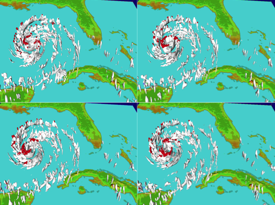
To test this theory, Reisner and colleagues at LANL spent months developing a lightning model that they’ve integrated into HIGRAD, one of the lab’s leading-edge fluid-dynamics models. Coupled to a cloud model, the simulation is as close as anyone’s gotten to mimicking lightning observed in a real hurricane.
Recently, Reisner released results of two intensive comparisons of the HIGRAD model with data on electrical activity from Hurricane Rita (2005) and dual-Doppler radar data from Hurricane Guillermo (1997). Researchers amassed some of the most detailed field data ever from both storms by using storm-chasing planes and ground-based lightning detection networks, including the Los Alamos Sferic Array.
In comparing the simulations and the real hurricanes, one thing already is clear: It’s going to take a lot more initial detail to accurately predict hurricane intensification.
“At the heart of the issue is that you need a lot of data,” Reisner says. “A hurricane is a big animal. It’s not like a super-cell thunderstorm that produces a tornado; it’s much bigger than that. It’s composed of many super cells or thunderstorms. We’re finding that you need approximately 200,000 data points to really constrain a hurricane model in terms of properly initializing it and constraining key parameters that maybe can be used to predict a hurricane.”
To run such an enormous simulation, Reisner’s team used Jaguar, a Cray XT at DOE’s Oak Ridge Leadership Computing Facility.
“Jaguar enabled us to do stuff that no other computer at the time could do,” Reisner says. In total, Reisner’s group ran an ensemble of 120 simulations for Hurricane Guillermo that used approximately 118,000 Jaguar processors.
The simulations used a “matrix-free Ensemble Kalman Filter,” a technique that enables the integration of large amounts of real-world data. And, Reisner says, it appears that not just more but also different types of initial real-world input, such as lightning data, will be required to forecast changes in hurricane intensity.
“The thing that worries me now, based on my research, is that we may have to characterize somewhat the ocean surface,” Reisner says. “This means the complex surface wave field, sea spray and water temperature that is responsible for producing the water vapor flux that gets fed up into the hurricane.”
Prediction frontier
Although Reisner’s results show a link between a hurricane’s building strength and increasing rates of intra-cloud lightning, it’s too early to use this as a predictor.
“There’s a lot of pressure on the people who run these predictive models (when there’s a real hurricane), and my research is setting the tone for what goes into them 10 years down the road,” he says.
Reisner points to two improvements in data and modeling that will facilitate this.
The growth of new lightning networks, such as the World Wide Lightning Location Network, will provide an unprecedented level of detail on tropical-storm lightning activity, including hints at the microphysical conditions driving the lightning.
More accurately integrating this microphysical data into models is the next step. The HIGRAD simulations involved a range of scales from millionth-of-a-meter-sized water droplets to the entire span of the Gulf of Mexico. Integration across these scales will be aided by improved high-performance computing software and hardware that will be able to handle increasingly data-intensive models.
The jury’s still out on whether changes in a hurricane’s lightning bursts will be the cue to evacuate a coastal city, but the storms Reisner has swirling in supercomputers today will definitely help hurricane forecasters see more clearly.