Earth’s multimodel future
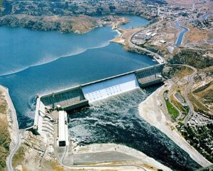
The Grand Coulee Dam on the Columbia River in Washington state is the United States’ largest hydroelectricity producer. A Pacific Northwest National Laboratory-led project aims to integrate models that show a changing climate’s impacts on rivers and other vital natural resources. (Photo: U.S. Bureau of Reclamation.)
In a climate-altered and ever-changing world, it’s important to understand the impact human activities have on natural resources and vice versa. How will climate change and other human behaviors affect food production, water usage and energy demand – and how can industries adapt?
A multi-university and national laboratory effort called Integrated Multisector, Multiscale Modeling (IM3) aims to answer these and many other questions. The project started more than three years ago with support from the Department of Energy’s MultiSector Dynamics program area and leadership from Pacific Northwest National Laboratory (PNNL). IM3 arose from a PNNL internal initiative called the Platform for Regional Integrated Modeling and Analysis (PRIMA), which simulated the complex interactions between climate, energy, water, land and related systems at scales precise enough to aid land use planning and management.
Project leader Ian Kraucunas stresses the importance of combining these sectors because they can help answer science questions that cannot be answered with any one. Earth system changes include not only temperature and precipitation but also human impact on natural resources. For instance, in many places irrigation practices are altering water availability as much as climate change. “It is important to take both human and natural systems into account when you’re trying to think about long-term changes to a specific sector, like energy,” he says.
One area the IM3 team is especially keen to study is how earth-system changes affect electricity capacity expansion. Utilities have been limited in incorporating long-term climate change models into energy-use forecasts. And because capacity is developed based on peak load – the amount of electricity required on the hottest summer day – modeling tools weren’t projecting power needs a few decades hence based on the hottest days getting hotter. “Many of them were formulated assuming static climate at least implicitly, if not explicitly,” Kraucunas says.
To help utilities adjust to the warming climate, the IM3 team has developed tools that can simulate the influence of environmental changes on the electric power sector – including hydropower operations, building energy demand, and capacity expansion. IM3 devises both proprietary tools for private companies and open-source, publicly available programs.
By combining multiple models that represent the supply and demand for water, energy and other resources, IM3 team members also found a surprising result: Moving to a biofuel-intensive energy system could lead to greater water scarcity in some regions than would occur under a business-as-usual scenario.
In a separate study, Kraucunas’ group is examining the realism of electricity capacity expansion scenarios. They use the Global Change Assessment Model (GCAM), a tool that helps explore alternative future states of the world. GCAM can be run under specific climate policies or geopolitical constraints, for instance, to see how many power plants would be needed to meet projected demand. But that’s where the model ends: It assumes that all of those plants could actually be constructed. “That’s not necessarily a good assumption,” Kraucunas explains. “You’d have a hard time siting a large new power plant that requires a lot of cooling water on a river that already experiences low flows due to droughts or because the water is already allocated to other uses.”
In summer 2018, he and his colleagues released the Capacity Expansion Regional Feasibility (CERF) model to calculate whether the power system scenarios in GCAM are feasible. CERF has a 1-square-kilometer-resolution across the United States and accounts for transmission lines, water resources, regulatory constraints and other factors that determine where power plants could be placed, including the cost and projected revenue of operating a certain kind of facility in a given location.
IM3 researchers also are investigating how human modifications of the land surface – irrigation, fertilization, urbanization – can affect regional hydrology and climate.
PNNL earth scientist Maoyi Huang leads much of this work. She and her colleagues are harnessing supercomputer power to simulate U.S. land use and land cover change at different resolutions using the Community Earth System Model (CESM), a global climate code that provides computer simulations of past, present and future conditions.
Huang has been awarded 2 million processing hours at the National Energy Research Scientific Computing Center at Lawrence Berkeley National Laboratory, a DOE user facility, to run simulations at different resolutions, studying whether regional climate projections for temperature and precipitation can be improved at higher resolutions, and whether land use and land cover change can contribute to regional climate variations.
“Previous generations of land models do not simulate crop growth and land management in very realistic ways,” Huang says. “We’re trying to mimic human activities and their consequences in the real world.” Early results show that accounting for land use and land cover change improves temperature and precipitation simulations in CESM.
In addition, the team has learned how irrigation affects regional climate by lowering the temperature – which is expected if water is added to any patch of land, owing to processes such as evaporation and transpiration.
But there are always tradeoffs when it comes to water management, Huang warns. More irrigation could boost agricultural activity but reduce streamflow, leaving less water available for human use downstream. “People tend to care more about local processes,” she says, “but we as earth scientists are thinking about the systems as a whole. We need to think about consequences both regionally and globally.”
Although IM3 findings are not meant to inform action immediately, Huang, Kraucunas and their colleagues are eager to develop tools that can take a more realistic look at the future of water use, energy and other key sectors. “There’s still a lot of work to be done,” Kraucunas says. “But that’s where we’re headed: What are the tools and what effects are these models missing that we could potentially help provide?”
About the Author
Wudan Yan is a Seattle-based freelance science writer.